
Scrooby Central
Scrooby Central, an area of land (circa 13.18 ha) located between the former Scrooby North working area to the north (now restored and a local wildlife site) and the existing Scrooby South sand and gravel working area.
The site comprises an area of cultivated agricultural land, which gently declines in gradient west to east from 15 to 7m AOD. The site is bordered by the A638 to the west, partly screened form view by established boundary planting and to the north by land, which was the route of a former mineral railway line serving Harworth Collery and in part, the now restored Scrooby North working area and Local Wildlife Site.

Viewpoint from east towards A368 - Scrooby Central
Click on the above image to view a larger version
Technical Design
The proposals are being designed taking account of a range of technical assessments which address:
Transport
Landscape and Visual
Ecology
1
2
3
Ground Conditions
Climate Change
Socio-economics
4
5
6
Ecology
Ground Conditions
Noise and Vibration
7
8
9

The Proposals

The proposed working scheme
Click on the above image to view a larger version
-
The proposed development would see the extraction of some 620,000 tonnes of sand and gravel at a rate of 40,000 tonnes per annum
-
Restoration will be to a conservation waterbody, with landscaping which together provides for biodiversity gain
-
The site will be worked in three broad phases, with working continuing from Scrooby South, with a single advancing face working in a northerly direction to the site boundaries
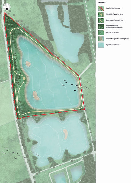
Proposed nature conservation restoration
Click on the above image to view a larger version
-
All minerals won will be transported to Scrooby Top Quarry via the existing haul road located on the site’s boundary, connecting to the existing access point which serves Scrooby South Quarry
- For routes refer back to Location and Context page